
April–May: spring in the valleys
Warmer weather brings green landscapes and comfortable city sightseeing. Higher trails and mountain passes may still have snow, so check local conditions before planning a trek.
This Tajikistan travel guide brings together practical planning advice for the country’s high mountains, historic cities and remote road journeys. Start in Dushanbe, explore the Fann Mountains and Seven Lakes, or plan a longer drive along the Pamir Highway. Distances can be deceptive: mountain roads are slow, services are sparse outside towns and weather can change plans.
Before booking, check whether your nationality needs a visa, allow enough time for a tourist e-Visa, and request a separate GBAO permit if your route enters the Gorno-Badakhshan Autonomous Region. The sections below cover the best time to visit Tajikistan, key destinations, local transport, money, connectivity, food and safety.
Visa requirements depend on nationality and route. Check your eligibility and permit needs before booking.
See the full Tajikistan tourist visa guide for entry rules, documents and permit details.
The best time to visit Tajikistan depends on altitude and your route. Mountain weather is different from the lowland cities, and road access can change from year to year.
Warmer weather brings green landscapes and comfortable city sightseeing. Higher trails and mountain passes may still have snow, so check local conditions before planning a trek.
This is generally the most practical season for trekking and Pamir Highway journeys. Expect strong sun, cold nights at altitude and occasional disruptions; carry layers and keep plans flexible.
Lower elevations can be visited year-round, but winter brings cold, snow and shorter days. Mountain roads and high passes may be difficult or closed; verify access before setting out.
Build a Tajikistan itinerary around the capital, historic northern cities and the mountain landscapes that make the country distinctive.
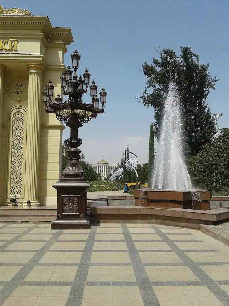

Use the capital as your first stop for museums, parks, markets and a taste of modern Tajik city life. Visit the National Museum, Rudaki Park and the large flagpole area, and keep a day for the Hissar Fortress outside the city.
The Fann Mountains are a popular base for hiking, alpine scenery and lakes. Iskanderkul is a well-known day or overnight trip from Dushanbe; allow extra time for the mountain road and check seasonal access.
The M41 crosses remote, high-altitude landscapes between Dushanbe and the GBAO region. Khorog is a common base for exploring the Pamirs. Plan several days, arrange suitable transport and obtain the required GBAO permit.
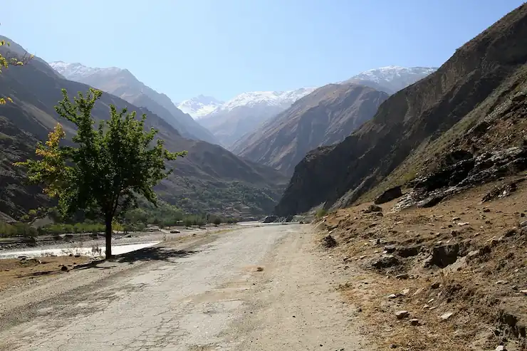
This remote mountain valley follows the Panj River through highland villages and dramatic scenery. It is best added to a longer Pamir route with a driver who knows local road and permit requirements.
One of Tajikistan’s main northern cities, with a historic centre, Panjshanbe Bazaar and access to the Fergana Valley. It works well as a separate northern trip or overland extension.
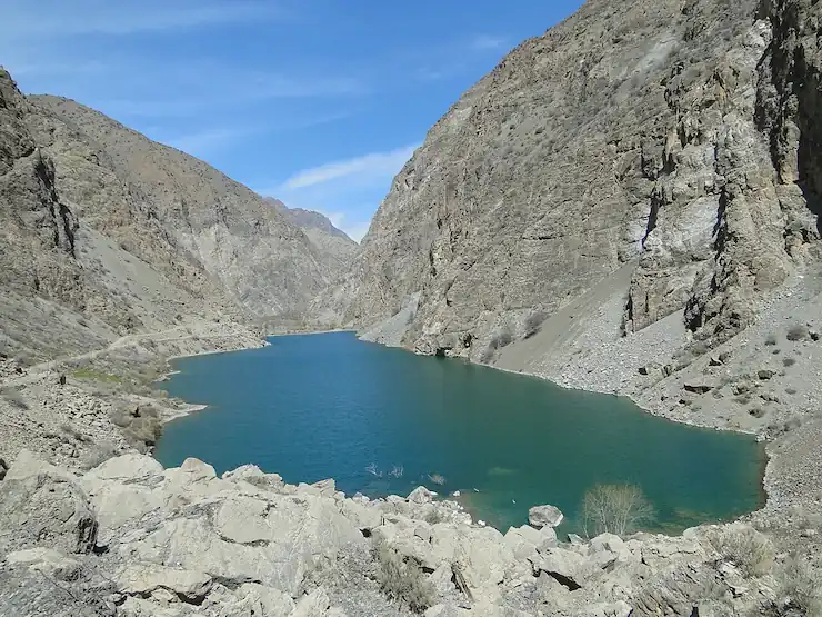
Visit the Haft Kul (Seven Lakes) area for mountain villages and changing lake colours, then explore Penjikent’s archaeological sites and the nearby ancient settlement of Sarazm.
Most international visitors arrive by air. Confirm current routes, entry requirements and local transport before you travel.
The main international gateway for the capital and many onward road journeys. Confirm airport transfers with your accommodation and allow time for city traffic.
Useful for northern Tajikistan when flights and dates suit your itinerary. Check current routes and onward transport rather than assuming daily service.
International land crossings connect Tajikistan with neighboring countries. Opening status, hours and entry requirements can change; verify the exact crossing before setting out.
Book your first night in advance, keep your hotel address offline and allow a buffer after arrival before connecting to a long-distance bus or shared car.
Carry the passport used for your visa application and keep a printed and digital copy of your e-Visa approval. Immigration officers make the final admission decision.
Recheck airline schedules, border status and current travel advice shortly before departure, particularly if your route includes a remote region.
A common way to travel between towns. Cars often leave when full, so departure times can be flexible; agree the destination and fare before boarding.
Minibuses serve many local and intercity routes. They are inexpensive but can be crowded and may not follow a fixed timetable; ask locally about the departure point.
Travel times through the Fann Mountains and Pamirs are much longer than map distances suggest. Build in daylight, weather and road-condition buffers.
A hired car with an experienced local driver is often the practical choice for remote sights and multi-day mountain routes. Confirm the vehicle, route, overnight stops and what the price includes.
Flights can save time on some routes, but schedules and weather disruptions vary. Check current service and leave a backup plan for onward connections.
Mountain roads may be rough, remote and exposed to sudden weather. If self-driving, confirm local licence and insurance rules, vehicle suitability and current route conditions.
Buy a SIM from an operator shop or authorised retailer and bring your passport for registration. Confirm current plans and coverage when purchasing.
Mobile data is most dependable in cities and larger towns. Coverage can be weak or absent on remote mountain routes, so download maps and important documents in advance.
Keep offline maps, a translation app, accommodation details and transport contacts available on your phone. Do not rely on mobile data for navigation in the Pamirs.
Wi-Fi is more common in city hotels and cafés than in villages or mountain guesthouses. Keep a power bank for long travel days.
Modest clothing is appreciated, especially when visiting mosques and religious sites. Ask locally about footwear and any visitor rules before entering.
Request permission before photographing people, homes or religious spaces. Follow posted restrictions at government buildings and sensitive sites.
Tea and food may be offered to guests. A polite greeting and thanks go a long way; learn a few Tajik or Russian phrases for everyday situations.
Tajik is the state language and Russian is also widely used, particularly in cities. English is less common outside tourism services; keep addresses written down or saved offline.
Check your government’s current travel advisory before departure and again before visiting border areas. Follow local instructions and avoid restricted locations.
High altitude, remote roads and limited rescue services make preparation important. Acclimatise gradually, watch for altitude symptoms and do not trek alone in unfamiliar areas.
Arrange travel insurance that covers medical treatment and evacuation, including planned high-altitude activities. Carry prescription medicines and a basic first-aid kit.
Mountain conditions can change quickly. Check road access with local authorities or a trusted driver, avoid rushing after dark and keep spare time in your itinerary.
Before you go: Save your accommodation details, insurance policy, emergency contacts and your country’s embassy or consulate contact offline. Keep copies of your passport, visa and GBAO permit separate from the originals.
Spend two days in Dushanbe, add Hissar Fortress, then use the remaining time for a nearby mountain or lake excursion if roads and weather allow.
Explore Dushanbe, travel toward Iskanderkul or the Fann Mountains, and continue to Penjikent and the Seven Lakes. Include a buffer for slow mountain roads.
Plan a multi-day route toward Khorog and the Pamirs only after arranging a suitable vehicle, checking current road access and securing the required GBAO permit.
Quick answers for visitors planning a trip to Tajikistan.
Visa rules depend on your nationality and trip. Some travelers are visa-exempt, while others need a visa or tourist e-Visa. Check the current eligibility rules before booking and apply while outside Tajikistan if required.
Late spring and early autumn are good for cities and lower-elevation routes. June to September is generally the most practical period for trekking and Pamir Highway travel, although mountain weather and road access can change quickly.
The national currency is the Tajikistani somoni (TJS). Cards and ATMs are more available in larger cities than in remote areas, so carry somoni cash for rural journeys and small businesses.
Travel in the Gorno-Badakhshan Autonomous Region (GBAO) requires a separate permit in addition to a Tajikistan tourist e-Visa. Request it with your visa application and check the approved dates and route before departure.
Allow at least a week for Dushanbe and a northern or Fann Mountains route. A Pamir Highway journey usually needs substantially more time because distances are long, roads are slow and conditions can change.
The Pamir Highway is a remote, high-altitude route with long driving days, limited services and changing road conditions. Arrange a suitable vehicle and experienced driver, carry essentials, and check current access and safety advice before setting out.
Cards may work at larger hotels, restaurants and shops in Dushanbe and other major cities, but acceptance and ATM access are limited in rural and mountain areas. Carry local cash and do not rely on card payments for a remote route.
Use bottled, boiled or properly treated water unless local authorities or your accommodation confirm the supply is safe. Carry water and purification options on long mountain journeys.
Tajik is the state language and Russian is also widely used, especially in cities. English is less common outside hotels and tourism services, so save key addresses offline and consider a translation app.
The tourist e-Visa validity window is 90 days and the permitted stay is up to 60 days. Check the dates and conditions printed on your approval; GBAO travel requires a separate permit.

Page feedback
Help us improve accuracy, speed, and content on this page.


